Up Sucker Creek

Up Sucker Creek
Photo Courtesy of the Lake Oswego Library

Thursday, April 9, 2015

Thursday SWEA meeting at 4:30 pm

SouthWest Employment Area Advisory Committee Meeting 

Thursday, April 9, 2015, 4:30 - 6:30 pm
Lakeridge Jr. High (formerly Waluga Jr. High)

This is a public meeting - the public is welcome and may make comments
Read the consultants' report prior to the meeting for a view of planning so far.

As the name suggests, the land use plan for the SWEA is intended to be about creating an area conducive to more employment other than existing, low intensity industrial.  Development would presumably be geared toward manufacturing, office and retail services, though it's starting to look like a mixed-use world just as so many other places these days.  If Metro gives grant money for planning, you know what to expect.

Mixed-use is the new land use theory in style today.  Imagine every commercial area of Lake Oswego awash in 3+ story buildings with residential units on the all floors or just the upper floors, then you have an idea of what the planners have in mind for our city.  That includes all of Kruse Way where building heights can go up to 150 feet, all of Lake Grove, all of the SW Employment Area and Foothills Mixed-Use Area (industrial zones are so un-cool and with a low-tax base), and all of downtown and Old Town.  There are also the Neighborhood Villages like Roaewood and Palisades where dense commercial and housing uses can occur.

I don't think residents of Lake Oswego are aware of, or are ready for, this kind of change to their city.  Even the single family neighborhoods will be under assault from builders dividing large lots into two or more for big homes, and altering forever the suburban character of the town.  What was and st ill is a predominately family-oriented, small, suburban town, is poised for dramatic change.  Other cities still have discrete zones that keep multifamily, commercial and industrial uses in separate zones, but the New Urbanist mixed-use, compact form has quietly crept into Lake Oswego development codes and zoning.  Hello Smart Growth.

Back to SWEA.  The consultant's report says the Transportation Plan (TSP) has plans for sidewalks along Lakeview Blvd. south of Pilkington.  This is curious because during the creation of the TSP, it was revealed that the traffic level on Lakeview was low and the road did not rise to the level of an upgrade that would need sidewalks or other improvements.  Kittelson and Associates advised that Lakeview Blvd. was not a good candidate for elevation to a higher level with wider lanes and sidewalks.  Lakeview has a 38' ROW when the plan calls for 60',

The homes abutting the industrial land flood during heavy rains due to un-permitted paving on the former Pacific Lumber site that allows water to run off to private homes rather than drain on site.  Increased traffic, parking, expanded ROW with sidewalks would greatly impact the livability of the Rosewood neighborhood.  Is anyone paying attention?   The city can't or won't address basic sanitation (effluent seepage) and water drainage issues caused by property in the city.   No doubt the city is waiting for a wholesale urban improvements before they touch the problems of county residents, but this is immoral and it is easy to fix.  The property owner is the responsible party - the city should enforce its codes.

This is just ONE of the many problems that are evident in the SWEA plan.  While consultants,
planners, property owners and developers make their grand plans, they need to consider conditions here on Earth, and the effects on real people living in the area and in the city as a whole. Can we afford their plans?  Watch and see how the plan develops over the next few months.  Is this what the citizens of LO want?  Are they staying true to the city goal of making this a functional "Employment Area" with a lot of new, well-paid jobs?

Who is going to pay for all of this?  I sense another Urban Renewal District coming...  Noooo!  Will the RR allow one more at-grade crossing at Jean Rd.?  Probably not.  

The alternatives presented so far seem to concentrate on the intersection of Jean Rd. and Lakeview Blvd.  The entire area has not been fleshed out, but you can get an idea of where they are going.  Time to get your 2-cents in.   See the full report for detailed explanations of the draft plan.

ALTERNATIVE 1


ALTERNATIVE 2


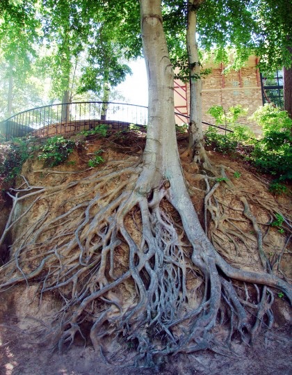
The patience of trees

Hungry Trees

Leaving one's bicycle next to a tree and forgetting about it seems to be a common mistake.  Then there are fences, headstones, and whatever else is in a tree's path - the tree just consumes the obstacles in its way.  This is a good time to check behind your trees to see what might be forgotten there.  Click to enlarge photos.


Wednesday, April 8, 2015

Critique of 2015 Council goals

Guiding the Council and Staff
(Who is guiding whom?)


At the City Council meeting last night (4/7/2015), the Council approved a list of 8 policy-related goals for the year.  The policies reflected here will be used "in guiding the work of both the City Council and staff".

Below are my comments regarding the list.


1.  Neighborhood Livability:  "to preserve the character of existing established residential neighborhoods".  The goal does not address neighborhood character.  "Character" is a word that is verboten in City Hall these days because it is subjective - not to the residents of a neighborhood who can explain very clearly and objectively what elements make up the character of their neighborhood - but to the planning staff and developers who hate the term because it doesn't allow them build what they want.  Even though neighborhood character, values and livability are encoded in Neighborhood Plans (approved by city councils), the new policy brings the issue back to Council to decide what parts of "neighborhood livability" will be preserved or sacrificed.  Forget character.

2.  Preservation of Assets

3. Annexation:  The policy calls for "friendly annexation" of residential areas, but unlike councils of the past that extended this policy to industrial/commercial areas as well, this policy takes a different tack.  "The City, however, take an active role in the annexation of developed commercial and industrial property within Lake Oswego's urban service area".  Would eminent domaine be used to grab land for private development, or just grab properties that would fatten up the property tax base?  I need an explanation for this one.

4.  Economic Development:  Development should "build the city's property tax base, provide jobs for Lake Oswego residents…"  Worthy goals, but in the Southwest Employment Area, the two newest businesses are a self-storage facility and Goodwill.  The storage facility will employ how many people?  And as a warehouse, how valuable will the property be?  Similar story for Goodwill, but on a bit higher scale.  This is really not worth the effort of a grand plan for the small industrial area if this is what we get.

"Reducing regulatory barriers" "without sacrificing community aesthetics" -- translation:  build to the maximum density, and only the staff will be able to decide if anything meets code, no more citizen input or Development Review process.  Do you trust your planners? Even the City Council will not have the power to change things.

5.  New Fees and Taxes; Debt:  This one is fun.  New fees or taxes will have to be dedicated to a specific purpose.  Since public funds are fungible, the new income will only replace other general fund dollars and allow for more spending wherever it is wanted.  A limit on debt excluding voter-approved general obligation bonds is only good if the debt is low enough and wisely to persuade voters their money is being spent for necessities.

6.  Property Rights

7.  Objective Development Standards and Community Involvement:  This would take a book.  I do not agree that the only way to meet state requirements for clear and objective housing standards is to remove the development review commission and citizen input from the process.  Making permit approval subject only to planners' ministerial approval is wrong and we should not be following this path - it will not go well.

8.  Sustainability:  What can I say.  This is a regurgitation of the United Nations definition of sustainability that everyone uses these days.  It makes me wonder if anyone thinks for themselves these days.  What does sustainability mean for Lake Oswego?  This word is used so liberally, its true meaning is lost, but by gosh, we all have to have it in there somewhere!  Way to go!

The understory of trees

What happens underground is visible above.  


Tuesday, April 7, 2015

Trees as living art

It's amazing what people can do with trees, considering imagination it takes, and the commitment over many years to train a trees' growth and keep it alive.

It's Arbor Week - have fun with your tree.
 Arborsculpture


Willamette Shore Line: What do citizens want?

Council member, Jeff Gudman has bee championing the idea of making the Willamette Shore Trolly line into a bike and pedestrian path for quite a while, and the Council made investigation into the practicality of doing so one of their goals for 2015.  Gudman has been on a mission ever since.

In a perfect world, a bike/ped path along the river is a great plan.  There are a few logistical, geological, legal and financial problems though, along with public support for building and paying for a path.
  • Trimet is looking for "direction and resources."   We're tapped.  Where is the money and demand coming from?
  • How many bike users or walkers would actually use the path?  If this was a toll path - how much would it cost each user to pay for it?
  • The Elk Rock tunnel is an engineering dilemma for its stability during an earthquake, and a security risk for users the rest of the time.  
  • Property owners abutting the right of way might object to people cycling or walking by their homes, 24/7.  Homeowners on the Springwater Trail know don't like it.
  • The streetcar was not a widly popular plan for the trolley line.  Without solid majority public support, any plan is a no-go.  But the politicians already know that.
  • Then there is that old bugaboo, citizen involvement.  When do citizens get a chance to weigh in on this land use /transportation plan, or the original streetcar plan for that matter?  Before or after all the planning is done? Or is this just a "big boys' and girls'" game and we are just the paying spectators?  
  • Why is Lake Oswego taking the lead on this plan?  Does this include the lead investment also?  Who has the most to gain from this plan?
In short, what are Jeff Gudman's and the Council's goals for the trolley track?  Let's find out now, before the train, uh, bikes, get too far down the rails.  Let's also demand a voice in how our city looks in the future, and not just through controlled open houses for the well-connected. 

TriMet offers qualified support for Portland-Lake Oswego bike path
The Oregonian, April 6, 2015  Editorial

Back in 1988, a consortium of seven government entities bought the right of way formerly plied by the Willamette Shore Trolley with the intention of preserving it for future rail use. A proposal to run the Portland Streetcar along the route collapsed in 2012, but the hope remains. 

Gudman is on a crusade of sorts to make better use of the right of way. This year, he urged his fellow councilors successfully to include the development of a multiuse path among the city's goals, and he's sought support among local government officials and consortium members, which include, among @others, TriMet, Lake Oswego, Portland and Metro. The idea, Gudman says, is to move carefully by stages, identifying complications and costs and regularly gauging the interest of those involved in continuing.

The next step for Gudman and Lake Oswego: Convince consortium members to provide, in McFarlane's words, "direction and resources" to TriMet, the group's property management representative, to dive into what is likely to be a tangled property-rights thicket. 


*
While the current talk about a bike path continues, it is worthwhile to look back just 4 short years to the streetcar controversy to see why the public is not on board with the editorial's statement, that despite a collapse in plans for the Portland Streetcar along the trolley route, "hope remains."  That hope is held by downtown and Foothills property owners, developers, and pro-development city bureaucrats rather than by the general public who would be picking up the tab for the others' financial gain.


Plan to build $458 million Portland to Lake Oswego streetcar raises questions
The Oregonian, March 26, 2011 By Brad Schmidt

"The streetcar is really a means to an end," said Brant Williams, Lake Oswego's director of economic and capital development. "The end is really what our downtown and Foothills area will look like."

Critics also question the project's close ties to redeveloping Lake Oswego's 107-acre Foothills District, at the end of the proposed line.

According to a predevelopment agreement with Lake Oswego, Portland company Williams/Dame & White -- Homer Williams' company -- can walk away if streetcar planning doesn't move forward. Williams' notable projects in the Pearl District and South Waterfront also feature streetcar access.

"Without the streetcar, the project becomes very unviable from a financial standpoint," said Matt Brown, a development manager for the company.

"It is unconscionable to be spending public dollars on this project that makes no economic sense, that serves so few people, and is basically putting money into the pockets of Homer Williams and his firm, the Obletz firm, and making a name for a few public officials," said Dunthorpe resident Elizabeth English, whose property abuts the right of way.

Monday, April 6, 2015

Trees = love and harmony

If you are lucky enough to OWN a tree, go hug your tree.  Sometimes governments make it seem like your tree belongs to them, but hang on tight!

Enjoy Arbor Week

 Love and harmony combine, 
And around our souls entwine, 
While thy branches mix with mine,
And our roots together join.   
Joys upon our branches sit,
Chirping loud and singing sweet; 
Like gentle streams beneath our feet 
Innocence and virtue meet.   
-William Blake


Sunday, April 5, 2015

Green blobs bombs big time

And we paid what for these things?  

As seen in the most recent Hello LO - the City's new park signs have many detractors. The modern, antiseptic, neon shapes do not reflect the character of either the city or our lovely parks.  I heard one person compare the signs to Walmart's, and not in a good way.  Turns out he was right.  Why not save the cash, and keep our old signs, and keep our well-earned identity instead.


"There will be no UPZONING"

How small can you go in LO?  


According the the Community Development Codes, there is no minimum size for a dwelling unit in LO.  So how small can housing units be, and how many individual structures and dwelling units can be crammed onto a single lot?  If the units are small enough, if the structures are several stories, if no parking is required... the number expands like a dandelion weed in summer.

WHY have small, group housing units become an issue in LO?  Why now?  HOW does this fit city or neighborhood character goals?  

The answer to the third question is, it doesn't.  

The first and second questions?  You could see this one coming several years ago when planners included "cluster housing" in draft Comp Plan language.  They claimed there was a strong preference for small, clustered housing, though surveys were so poorly constructed that no such conclusion could reasonably be made. At the time, there was no zone or development code that would allow such develooment.  Citizens (USC included) objected to cluster housing as it allowed up-zoning (increased density) in residential areas in opposition to Comp Plan goals for preservation of neighborhood character.  Planners repeatedly promised that UPZONING was not going to happen.  The idea went dormant, but it came back just as the Comp Plan code audit got underway.  

A potential new development code type is in the works, and the egregious, intentional, convoluted interpretation of the definition of a duplex (how hard is it to define a duplex anyway?) in zone R-2 is the foot in the door to get it done.  The potential new development type is called, "multi-dwelling development" that is defined as "a grouping of individual residential structures on one lot, where each structure contains one or more dwelling units."  Note: "potential" usually means "will be".   Once draft plans and codes are written, the planning staff seems to have the authoritative upper hand.  Why?  

The details have not been fleshed out yet regarding specific lot or building dimensions (area, height, stories, lot coverage, setbacks), compatibility with neighboring homes, parking requirements, etc., but multi-dwelling development would be intended for medium and high density zones, R-0, R-2, R-3, R-DD, and R-5.  The dwelling units could be on one lot, or a collection of lots to cover a larger area with more units.

What specifically do the planners have in mind?  They aren't really saying.  Any monkeying with multi-dwelling, multi-family density would add to the un-challengeable, un-appealable, ministerial-only, developer-friendly permit approval process approved under the Clear and Objective Housing Standards.  

Here's the thing: A proposal for a new type of development preempts our elected City Council's prerogative to establish policies regarding land use and residential density.  Staff merely responds to Council direction.  The Council has not had this discussion, and the intent of a new residential development type and codes have not been spelled out.  Let's put first things first:  Scrap this plan, work on the duplex thing, keep it simple.  This is a solution without a problem.  

Not specified in the Planning Commission Staff Report, the diagram below suggests lot coverage could be about 50%. In a R-5 zone, this might mean 500 SF units, though minimum dwelling size is not established, and combined with max. heights, a development could allow XX units per acre.  How many is XX?  Best put this idea back on the shelf.

Read the report and send your comments to the Planning Commission prior to the Public Hearing date of April 27.


Wednesday, April 1, 2015

Woo Hoo! Now give us our money back!

Remember when the old Clackamas County Board of Commissioners borrowed about $20 million to give to the Portland-Milwaukie Light Rail project in 2012 - just days before an election that would have hampered their action - over loud protests from opponents ….

Well, the good news is that the PMLR project is almost done and is UNDER BUDGET!  Cause for celebration.  The savings will amount to about 3% of the total budgeted project total, I calculate (very rough estimations) that Clackamas County should receive a reimbursement of about $600,000.

Cheers!  I am sure the County can use it on roads or bridges or some useful transportation project.

Read the comments - there certainly a lot of Debbie Downers out there.  It seems many thing we won't get our money back, or that the numbers are faked.


TriMet: New MAX line millions under budget


TriMet says the Portland-Milwaukie Light Rail Line scheduled to open on Sept. 12 will come in millions of dollars under budget
Although the exact savings won't be known until 2019, the regional transit agency estimates the savings on the $1.49 billion project will be in the $10 million to $40 million range.
   Half of the cost of the project — called the Orange Line — is being paid by the Federal Transit Administration. It will recover 50 percent of the savings, an amount somewhere between $5 million and $20 million. The final figure will not be known until the federal appropriations conclude, according to TriMet.